


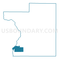
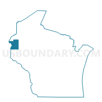
FARMINGTON - T 1 Voting District, Polk County, Wisconsin
About
Outline

Summary
| Unique Area Identifier | 696215 |
| Name | FARMINGTON - T 1 Voting District |
| County | Polk County |
| State | Wisconsin |
| Area (square miles) | 22.02 |
| Land Area (square miles) | 21.58 |
| Water Area (square miles) | 0.45 |
| % of Land Area | 97.97 |
| % of Water Area | 2.03 |
| Latitude of the Internal Point | 45.27484490 |
| Longtitude of the Internal Point | -92.68492330 |
Maps

Graphs
Select a template below for downloading or customizing gragh for FARMINGTON - T 1 Voting District, Polk County, Wisconsin


Neighbors
Neighoring Voting District (by Name) Neighboring Voting District on the Map
- ALDEN - T 3 Voting District, Polk County, WI
- FARMINGTON - T 2 Voting District, Polk County, WI
- Franconia Twp. Voting District, Chisago County, MN
- OSCEOLA - T 2 Voting District, Polk County, WI
- OSCEOLA - T 4 Voting District, Polk County, WI
- Osceola - V 2 Voting District, Polk County, WI
- Osceola- V 1 Voting District, Polk County, WI
- Scandia Voting District, Washington County, MN
Top 10 Neighboring County Subdivision (by Population) Neighboring County Subdivision on the Map
- Scandia city, Washington County, MN (3,936)
- Osceola town, Polk County, WI (2,855)
- Alden town, Polk County, WI (2,786)
- Osceola village, Polk County, WI (2,568)
- Farmington town, Polk County, WI (1,836)
- Franconia township, Chisago County, MN (1,805)
Top 10 Neighboring Place (by Population) Neighboring Place on the Map
Top 10 Neighboring Unified School District (by Population) Neighboring Unified School District on the Map
- Forest Lake Public School District, MN (45,564)
- Osceola School District, WI (9,074)
- Franconia Public School District, MN (178)
Top 10 Neighboring State Legislative District Lower Chamber (by Population) Neighboring State Legislative District Lower Chamber on the Map
- Assembly District 28, WI (59,273)
- State House District 17B, MN (49,009)
- State House District 52A, MN (47,548)
Top 10 Neighboring State Legislative District Upper Chamber (by Population) Neighboring State Legislative District Upper Chamber on the Map
- State Senate District 10, WI (192,662)
- State Senate District 17, MN (94,415)
- State Senate District 52, MN (90,197)
Top 10 Neighboring 111th Congressional District (by Population) Neighboring 111th Congressional District on the Map
- Congressional District 6, MN (759,478)
- Congressional District 7, WI (689,279)
- Congressional District 8, MN (660,342)
Top 10 Neighboring Census Tract (by Population) Neighboring Census Tract on the Map
- Census Tract 9608, Polk County, WI (6,465)
- Census Tract 9609, Polk County, WI (5,215)
- Census Tract 1106, Chisago County, MN (4,747)
- Census Tract 702.05, Washington County, MN (3,936)